


Cambodia: Cambodia Geography Profile
2015/02/19
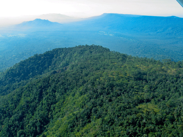
Cambodia is located on mainland Southeast Asia between Thailand to the west and north and Vietnam to the east and southeast. It shares a land border with Laos in the northeast. Cambodia has a sea coast on the Gulf of Thailand. The Dangrek mountain range in the north and Cardamom Mountains in the southwest form natural boundaries. Principal physical features include the Tonle Sap lake and the Mekong and Bassac Rivers. Cambodia remains one of the majority heavily forested nations in the region, although deforestation continues at an alarming rate.
Location: Southeastern Asia, bordering the Gulf of Thailand, between Thailand, Vietnam, and Laos
Geographic Coordinates: 13 00 N, 105 00 E
Area: 181,035 sq km (land: 176,515 sq km; water: 4,520 sq km)
Land Boundaries: 2,572 km (Laos 541 km, Thailand 803 km, Vietnam 1,228 km)
Coastline: 443 km
Maritime Claims:
-
territorial sea: 12 nm
-
contiguous zone: 24 nm
-
exclusive economic zone: 200 nm
-
continental shelf: 200 nm
Natural Hazards: monsoonal rains (June to November); flooding; occasional droughts
Terrain: mostly low, flat plains; mountains in southwest and north. The highest point is Phnum Aoral (1,810 m) and the lowest point is the Gulf of Thailand (0 m).
Climate: tropical; rainy, monsoon season (May to November); dry season (December to April); little seasonal temperature variation
Cambodia has seven ecoregions that occur entirely or half within its borders:
Tonle Sap freshwater swamp forests
Tonle Sap-Mekong peat swamp forests
Central Indochina dry forests
Cardamom Mountains rain forests
Indochina mangroves
Southeastern Indochina dry evergreen forests
Southern Annamites montane rain forests
Tonle Sap freshwater swamp forests
The swamp shrublands and forest of the Tonle Sap Freshwater Swamp Forests ecoregion include two forest associations that have been described for the extensive floodplain area of Tonle Sap, a short tree shrubland covering the majority of the area and a stunted swamp forest around the lake itself. Similar swamp forests are as well present along floodplains of the Mekong and other major rivers in Cambodia. Although most of the ecoregion, inclunding the lake, was declared a protected area recently, it was too little too late. The protected area is a paper park with no protection or management, and it was declared protected next most of the habitat had been cleared for agriculture. This is prime rice-growing habitat.
Tonle Sap-Mekong peat swamp forests
The Tonle Sap-Mekong Peat Swamp Forests are only a small vestige of their former range and function. They extend over areas permanently inundated with shallow freshwater, although the region as mapped includes mosaics of swamp forest and herbaceous wetland interposed with upland areas of dry forest. However, care must be given in separating permanently flooded swamp forests of southeast Asia from seasonal swamp forests that characterize extensive areas of the Tonle Sap Basin and the floodplain of major Cambodian rivers. Additional than 90 % of this ecoregion has been converted to scrub or degraded forests. Intensive agriculture and the alteration of the hydrodynamics of the river systems in the region have altered the natural river fluctuations, adversely affecting the remaining native vegetation.
Central Indochina dry forests
The Central Indochina Dry Forests ecoregion covers most of central Indochina and harbors an outstanding assemblage of threatened large vertebrates that characterize the mammal fauna of the Indo-Pacific region. Just half a century ago large populations of megaherbivores such as Asian elephants, banteng, kouprey, gaur, wild water buffalo, and Eld's deer roamed and grazed in these dry woodlands. Where human densities were still low, the landscapes were dominated by large herds of wildlife reminiscent of the savannas of east Africa. Large carnivores such as tigers, Clouded Leopards, leopards, and packs of wild dogs hunted these herbivores. Unfortunately, throughout the ensuing years habitat loss and hunting for trade have exacted a devastating toll on these species. Some species have even become extinct. The two rhinoceros species, the Javan and the Sumatran are presently extinct in this ecoregion, as is Schomburgk's deer. The kouprey probably is globally extinct, although intermittent reports from remote areas of northern and eastern Cambodia keep hopes alive. Part the other species, the tiger, Asian elephant, Eld's deer, banteng, and gaur are endangered.
Cardamom Mountains rain forests
The Cardamom Mountains Rain Forests ecoregion sits astride the Cardamom Mountains (locally known as Kravanh) and the Elephant Range (locally known as Dom rei) in southwestern Cambodia and extends slightly across the border into southeastern Thailand.
It is separated from the nearest other rain forest by the vast, dry Khorat Plateau in central Thailand to the north and east and by the Gulf of Thailand in the west.
The Cardamom Mountain rain forests are considered by some to be one of the majority species-rich and intact natural habitats in the region, but they are as well one of the least explored.
Because of the low human people of this ecoregion, the forests in Cambodia are relatively intact; however, the areas in southeastern Thailand have been greatly reduced and presently exist only in a few protected areas in hilly regions. Sixteen protected areas cover about 14,500 km2 (33 %) of the ecoregion (Table 2). Six of these protected areas—Aural, Phnom Bokor, Botum-Sakor, Roniem Daun Sam, Khao Ang Ru Nai, and Phnom Samkos—are larger than 1,000 km2. Phnom Samkos National Park exceeds 3,000 km2.
Despite this high level of formal protection, very few reserves have effective management and workforces; they are paper parks. Several are presently under threat from illegal logging operations and from adjacent concessions that encroach on the unprotected protected areas. The wildlife trade has as well resulted in widespread hunting throughout Cambodia and Thailand, exacting a heavy toll from endangered wildlife populations. The widespread presence of antipersonnel land mines pose severe threat to both wildlife and humans (inclunding researchers).
Indochina mangroves
Part the majority diverse and extensive mangrove ecosystems in the world, this ecoregion provides extremely significant habitat for some of the world's rarest waterbirds. The major block of Indochina Mangroves in the Mekong River delta suffered large-scale habitat loss from defoliants sprayed during the Vietnam War.
Mangrove forests occur in coastal areas of regular flooding by tidal or brackish water and develop on saline gleysols. The extent of mangroves in coastal areas of Thailand, Cambodia, and Vietnam was once high, but much of this area has been destroyed. Extensive mangrove forests once occurred in the areas of Veal Renh and Kompong Som Bays in Cambodia. The absence of additional extensive mangrove stands in Cambodia is strongly related to the rocky coastline and lack of major estuaries or river deltas.
This ecoregion is highly threatened in nearly each site where it occurs. About half of the mangroves in southern Vietnam were destroyed by Agent Orange, tank movements, and bombing during the war. Since again, however, the government has launched a large-scale reforestation program. Although protected areas have been created to conserve these mangroves-seven small protected areas (average size of only 117 square kilometers (km2)) cover a mere 820 km2 (3 %) of the ecoregion-the majority of the ecoregion is threatened by a multitude of human activities
Southeastern Indochina dry evergreen forests
The Southeastern Indochina Dry Evergreen Forests ecoregion is globally outstanding for the large vertebrate fauna it harbors within large intact landscapes. Part the impressive large vertebrates are the Indo-Pacific region's major herbivore, the Asian elephant (Elephas maximus), and major carnivore, the tiger (Panthera tigris). The inventory includes the second known people of the critically endangered Javan rhinoceros (Rhinoceros sondaicus)-comprising a handful of animals in Vietnam's Cat Loc reserve-Eld's deer (Cervus eldi), banteng (Bos javanicus), gaur (Bos gaurus), clouded leopard (Pardofelis nebulosa), common leopard (Panthera pardus), Malayan sun bear (Ursus malayanus), and the enigmatic khting-vor (Pseudonovibos spiralis), known to science only by a few horns.
But the ecoregion's conservation priority does not rest merely on its charismatic biodiversity. Importantly, it as well represents a rare instance of a nonmontane ecoregion with large expanses of intact habitat that can allow viable populations of these species to survive over the long term. Unfortunately, all is not well in this haven, for plans to log Cambodia's forests, where most of the large habitat blocks lie, will result in large-scale habitat loss and fragmentation. Therefore, the ecoregion has been placed on the critical inventory.
About two-thirds of the original forest in this ecoregion has been cleared or seriously degraded, particularly in Vietnam and Thailand, but the habitat is relatively intact in Cambodia. A few large forest blocks as well remain in Thailand and Laos. The thirty-one protected areas in this ecoregion cover 22,230 kilometers2 (18 %) of the ecoregion. In general, the protected areas in this ecoregion are large, with an average size of almost 750 kilometers2.
Most of the forests in Vietnam have by presently been restored by plantations. Shifting agriculture has further degraded some areas of this ecoregion. But the greatest threats presently are from large-scale logging concessions that have been granted to multinational companies by the Cambodia government; therefore, the conservation status has been changed from relatively stable to critical.
Hunting to supply the huge wildlife trade has created blank forests throughout most of the ecoregion. From small, homemade crossbows used to kill small mammals for local consumption to bombs hidden in baited traps to kill tigers and pitfall traps for elephants, hunting has taken a very heavy toll on wildlife. The ravages of war and conflict have as well had lasting effects; mines and bombs scattered across the landscape and the easy availability of automatic weapons that have restored the crossbows have had deadly consequences.
Southern Annamites montane rain forests
in the remote montane forests of Kontuey Neak, or "the dragon's tail"-in the extreme northwest of Cambodia, where the boundaries of Cambodia, Laos, and Vietnam meet-is globally outstanding for its biodiversity. The intact forests of the ecoregion are little explored; it takes two weeks of intense walking and braving hazards such as mines and bombs that lie scattered throughout the landscape to get to some of the remote areas of the ecoregion. But the known flora and fauna attest to the region's biological diversity, which includes some of Asia's charismatic fauna. Part the larger vertebrates, the tiger (Panthera tigris), Asian elephant (Elephas maximus), douc langur (Pygathrix nemaeus), gibbon (Hylobates gabriellae), wild dog (Cuon alpinus), sun bear (Ursus malayanus), clouded leopard (Pardofelis nebulosa), gaur (Bos gaurus), banteng (Bos javanicus), and Eld's deer (Cervus eldii) are better known.

Northern South America, bordering the North Atlantic Ocean, between French Guiana and Guyana
4 00 N, 56 00 W
South America
slightly larger than Georgia
1,703 km
tropical; moderated by trade winds
mostly rolling hills; narrow coastal plain with swamps
timber, hydropower, fish, kaolin, shrimp, bauxite, gold, and small amounts of nickel, copper, platinum, iron ore
NA
deforestation as timber is cut for export; pollution of inland waterways by small-scale mining activities
smallest independent country on South American continent; mostly tropical rain forest; great diversity of flora and fauna that, for the most part, is increasingly threatened by new development; relatively small population, mostly along the coast

- Cambodia News
-
- AFGHANISTAN: UNWTO: International tourism – strongest half-year results since 2010
- CAMBODIA: Chinese tourists in Cambodia surge 35.6 pct in 1st 5 months
- CAMBODIA: Cambodia starts to build China-funded stadium
- AFGHANISTAN: Higher earning Why a university degree is worth more in some countries than others
- AFGHANISTAN: Global growth will be disappointing in 2016: IMF's Lagarde
- ARMENIA: 2015 Euro-Asia Economic Forum in Xi'an,

- Trending Articles
-
- SOUTH AFRICA: Nigeria and South Africa emerge from recession
- BAHRAIN: Bahrain issues new rules to encourage fintech growth
- NIGERIA: Nigeria has been one of the hardest-hit economies due to its over-dependence on oil
- ARUBA: Director of Tourism Turks and Caicos after Irma: Tourism, visitors, hotels current status
- ANGOLA: Angola: Elections / 2017 - Provisional Data Point Out Qualified Majority for MPLA
- WORLD: How fair is our food? Big companies take reins on sourcing schemes


