Zambia: Zambia Transportation Profile
2015/01/26

Almost all of Zambia's industries, commercial agriculture, and major cities are located along the rail lines, which are often paralleled by highways. The Zambia Railways system consists of 2,157 km (1,340 mi) of track. The rail link with the Atlantic via the Katanga and Benguela railways to Lobito Bay in Angola has been affected by instability in Angola since the mid-1970s. Construction began in October 1970 on the Tazara railway, a 1,860-km (1,156-mi) line linking Dar es Salaam in Tanzania with Kapiri Mposhi, north of Lusaka; intended to lessen Zambian dependence on the former white-minority regimes of South Africa and the former Rhodesia (instantly Zimbabwe), the line (890 km/
LOCATION: 9° to 18° S; 23° to 34° E. BOUNDARY LENGTHS: Tanzania, 338 kilometers (210 miles); Malawi, 837 kilometers (523 miles); Mozambique, 419 kilometers (260 miles); Zimbabwe, 797 kilometers (498 miles); Namibia (Caprivi Strip), 233 kilometers (145 miles); Angola, 1,110 kilometers (690 miles); Democratic Republic of the Congo (DROC), 1,930 kilometers (1,193 miles).
LOCATION: 9° to 18° S ; 23° to 34° E. BOUNDARY LENGTHS: Tanzania, 338 kilometers (210 miles); Malawi, 837 kilometers (523 miles); Mozambique, 419 kilometers (260 miles); Zimbabwe, 797 kilometers (498 miles); Namibia (Caprivi Strip), 233 kilometers (145 miles); Angola, 1,110 kilometers (690 miles); Democratic Republic of the Congo (DROC), 1,930 kilometers (1,193 miles).
Equipment and operational problems have kept the railway from reaching its full potential, however, and rail cargo links with South Africa and Mozambique ports, passing through Zimbabwe, remain significant for Zambian commerce.
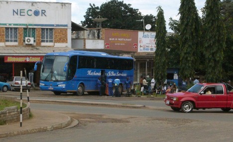
Zambia had 66,781 km (41,498 mi) of roadway in 2002. The principal routes were the Great North Road (809 km/503 mi), running from Kapiri Mposhi through Tanzania to Dar es Salaam, with a connecting road in Zambia from Kapiri Mposhi south to Livingstone (Maramba); the Great East Road (586 km/364 mi), from Lusaka to Chipata and thence to the Malawi border, with a connecting road (583 km/362 mi) from Mongu to Lusaka; the Zaire Border Road, from Kapiri Mposhi on the Great North Road through the Copperbelt region to Katanga, DROC; and the Kafue-Harare (Zimbabwe) road. Road services continue to play an significant role in transporting copper and general cargo to and from Dar es Salaam. Transport services on the major routes as well are provided by the National Transport Corp. of Zambia, the national-owned freight and passenger transport service. The United Bus Co. of Zambia is the major passenger carrier. In 2000, there were 173,400 registered motor vehicles, inclunding 64,000 passenger cars.
In 2001, there were 111 airports, only 11 of which had paved runways. Lusaka International is the principal airport. National-owned Zambia Airways is the national airline. Zambia Airways provides international service from Lusaka to several African and European nations, inclunding domestic service to 17 Zambian centers. In 2001, 48,500 passengers were carried on scheduled domestic and international flights
There are 2,250 km (1,398 mi) of waterways, inclunding Lake Tanganyika and the Zambezi and Luapula rivers. Mpulungu on Lake Tanganyika is Zambia's only port and receives goods supplied through Tanzania. There are several fishing harbors on Kariba Lake.
Infrastructure development, most particularly in rural areas, is one of the major needs for Zambia’s developments and is upheld in both the Fifth National Development Plan (FNDP), about to be completed, and the Sixth National Development Plan (SNDP), any minute at this time to be launched, inclunding in the National Vision 2030. Most of the infrastructure is still national-owned.
- Zambia News
-
- ZAMBIA: Zambia insists on fish import restriction despite deficit
- ZAMBIA: Zambian government hailed over move to increase tobacco taxes
- CHINA: Chinese-supported infrastructure projects change Zambia's landscape
- BOTSWANA: Africa: USA-Africa - No Policy? Bad Policy? or Both?
- BOTSWANA: Africa: U.S. State Department To Get Experienced Diplomat in Key Africa Post
- BOTSWANA: Africa’s economic growth in 2016 was driven by East Africa
- Trending Articles
-
- KENYA: Kenya to hold fresh presidential election on October 17
- HUNGARY: Hungary registers trade surplus of 5.4 bln euros in H1 2017
- KENYA: Kenya's overall inflation rate rises by 8 pct in August
- ZAMBIA: Zambia insists on fish import restriction despite deficit
- BOTSWANA: Africa: USA-Africa - No Policy? Bad Policy? or Both?
- BOTSWANA: Africa: U.S. State Department To Get Experienced Diplomat in Key Africa Post


