


Uganda: Uganda Geography Profile
2015/01/28
 is located in
LOCATION, SIZE, AND EXTENT
A landlocked country in east-central Africa, situated north and northwest of Lake Victoria, Uganda has a total area of 236,040 sq km (91,136 sq mi), of which 36,330 sq km (14,027 mi) is inland water. Comparatively, the area occupied by Uganda is slightly smaller than the national of Oregon. It extends 787 km (489 mi) nne–ssw and 486 km (302 mi) ese–wnw. Bounded on the n by Sudan, on the e by Kenya, on the s by Tanzania and Rwanda, and on the w by the Democratic Republic of the Congo (DROC). Uganda has a total boundary length of 2,698 km (1,676 mi).
TOPOGRAPHY
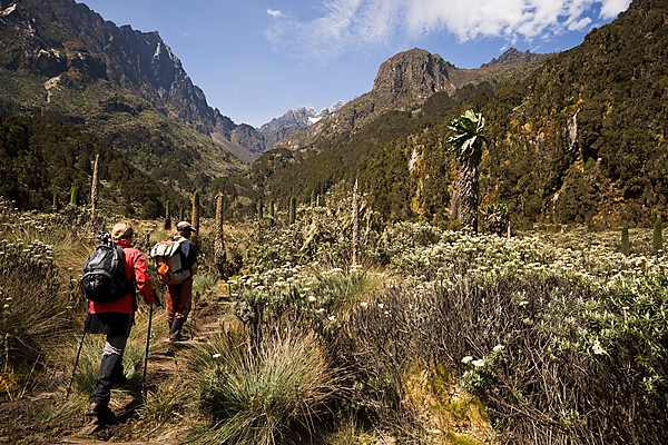
The better part of Uganda consists of a plateau 800 to 2,000 m (2,600–6,600 ft) in height. Along the western border, in the Ruwenzori Mountains, Margherita Peak reaches a height of 5,109 m (16,762 ft), while on the eastern frontier Mount Elgon rises to 4,321 m (14,178 ft). By contrast, the Western Rift Valley, which runs from north to south through the western half of the country, is below 910 m (3,000 ft) on the surface of Lake Edward and Lake George and 621 m (2,036 ft) on the surface of Lake Albert (L. Mobutu Sese Seko). The White Nile has its source in Lake Victoria; as the Victoria Nile, it runs northward through Lake Kyoga and again westward to Lake Albert, from which it emerges as the Albert Nile to resume its northward course to the Sudan. With 69 lakes, Uganda has the highest number of lakes in Africa.
CLIMATE
Although Uganda is on the equator, its climate is warm rather than hot, and temperatures vary little throughout the year. Most of the territory receives an annual rainfall of at least 100 cm (40 in). At Entebbe, mean annual rainfall is 162 cm (64 in); in the northeast, it is only 69 cm (27 in). Temperature generally varies by altitude; on Lake Albert, the mean annual maximum is 29°c (84°f) and the mean annual minimum 22°c (72°f). At Kabale in the southwest, 1,250 m (4,100 ft) higher, the mean annual maximum is 23°c (73°f), and the mean annual minimum 10°c (50°f). At Kampala, these extremes are 27°c (81°f) and 17°c (63°f).
FLORA AND FAUNA
In the southern half of Uganda, the natural vegetation has been largely restored by cultivated plots, in which plantain is the majority prominent. There are, however, scattered patches of thick forest or of elephant grass and mvuli trees, providing excellent timber.
The cooler western highlands contain a higher proportion of long grass and forest. In the extreme southwest, however, cultivation is intensive even on the high mountain slopes. In the drier northern region, short grasses appear, and there are areas of open woodland; thorn trees and borassus palms as well grow.
Elephant, hippopotamus, buffalo, cob, topi, and a variety of monkeys are all plentiful, while lion, giraffe, and rhinoceros as well are seen. At least six mammal species are found only in Uganda.
The birds of Uganda include the crowned crane (the national emblem), bulbul, weaver, crow, shrike, heron, egret, ibis, guinea fowl, mouse bird, lourie, hornbill, pigeon, dove, bee-eater, hoopoe, darter, lily-trotter, marabou stork, kingfisher, fish eagle, and kite. As of 2002, there were at least 345 species of mammals, 243 species of birds, and over 4,900 species of plants throughout the country.
There are relatively few varieties of fish, but the lakes and rivers contain plentiful stocks of tilapia, Nile perch, catfish, lungfish, elephant snout fish, and other species. Crocodiles, too, are found in a lot of areas and are particularly evident along the Nile between the Kabalega (Murchison) Falls and Lake Albert. There is a wide variety of snakes, but the additional dangerous varieties are rarely observed.
ENVIRONMENT
Major environmental problems in Uganda include overgrazing, deforestation, and primitive agricultural methods, all of which lead to soil erosion. Attempts at controlling the propagation of tsetse flies have involved the use of hazardous chemicals. The country's water supply is threatened by toxic industrial pollutants; mercury from mining activity is as well found in the water supply.
Forests and woodlands were reduced by two-thirds between 1962 and 1977. By 1985, 193 square miles of forests were eliminated. Between 1990 and 2000, the annual rate of deforestation was about 2%. Wetlands have been drained for agricultural use. As of 2003, 24% of Uganda's total land area was protected, inclunding two natural UNESCO World Heritage Sites and two Ramsar wetland sites.
In 1996, water hyacinth increase created a critical environmental and economic problem on Lake Victoria. By some estimates, the hyacinths covered 6,000 ha (14,820 acres) of water, still less than 0.1% of the lake. At the same time as the masses of hyacinths drifted into Uganda's ports and coves, they impaired the local fishing, trapped small boats in ports, and kept fish under the plants. The weed invasion had as well been known to affect cargo boat and ferry transportation by fouling engines and propellers and making docking difficult. Environmentalists introduced different types of pests to control the weed increase, so that by 2001, much of the increase had diminished. Of additional recent concern for Lake Victoria is the drop in water level that has occurred in from about 1995–2005. Some reports estimate that the water level had dropped by one meter in that decade.
According to a 2006 statement issued by the International Union for Conservation of Nature and Natural Resources (IUCN), the number of threatened species included 29 types of mammals, 15 species of birds, 6 species of amphibians, 27 species of fish, 10 types of mollusks, 9 species of other invertebrates, and 38 species of plants. Threatened species include the mountain gorilla, northern white rhinoceros, black rhinoceros, and Nile crocodile. Poaching of protected animals is widespread.
Eastern Africa, west of Kenya
1 00 N, 32 00 E
Africa
slightly smaller than Oregon
2,698 km
tropical; generally rainy with two dry seasons (December to February, June to August); semiarid in northeast
mostly plateau with rim of mountains
copper, cobalt, hydropower, limestone, salt, arable land, gold
draining of wetlands for agricultural use; deforestation; overgrazing; soil erosion; water hyacinth infestation in Lake Victoria; widespread poaching
Biodiversity, Climate Change, Climate Change-Kyoto Protocol, Desertification, Endangered Species, Hazardous Wastes, Law of the Sea, Marine Life Conservation, Ozone Layer Protection, Wetlands
strategic location near world's busiest shipping lanes and close to Arabian oilfields; terminus of rail traffic into Ethiopia; mostly wasteland; Lac Assal (Lake Assal) is the lowest point in Africa

- Uganda News
-
- BOTSWANA: Africa: USA-Africa - No Policy? Bad Policy? or Both?
- BOTSWANA: Africa: U.S. State Department To Get Experienced Diplomat in Key Africa Post
- UGANDA: Ugandan Govt Starts Verifying International Academy Teachers
- BOTSWANA: Africa’s economic growth in 2016 was driven by East Africa
- BOTSWANA: Africa property offers rich pickings for the brave
- BOTSWANA: Bill Gates sees US likely to maintain aid levels for Africa

- Trending Articles
-
- HUNGARY: Putin, Hungarian PM discuss new nuclear power plant
- CHINA: Xi Jinping opens BRICS Summit in Xiamen, asks members to shelve differences
- CHINA: Xiamen BRICS summit in China
- CHINA: The Mixed Fortunes of the BRICS Countries, in 5 Facts
- CHINA: BRICS Must Trust Diplomacy To Resolve Issues, Says China's Xi Jinping
- HUNGARY: Hungary's economy expands 3.2 percent in Q2

