
Central Africa Republic: Bangui City
2012/12/18
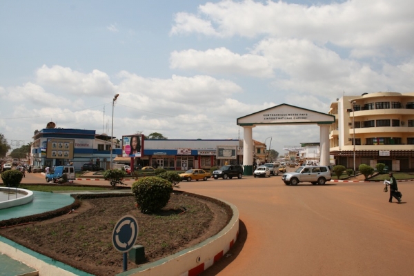
Bangui is the capital of and the major city in the Central African Republic. The majority of the people of the Central African Republic lives in the western parts of the country, near Bangui. Though surrounded by Ombella-M'Poko prefecture, it is an independent commune, thus administratively a part of no prefecture.
Geography
Bangui lies on the northern banks of the Ubangi River just below a series of rapids that limit major commercial shipping farther upriver, on the southern border. The navigable Ubangi River turns sharply south below Bangui and connects to the Congo River just south of the equator near Brazzaville as its chief northern tributary. The river marks the border between the Central African Republic and the Democratic Republic of the Congo (DRC). The Congolese town of Zongo sits opposite the river from Bangui.
The city centre lies near the river and features a large triumphal arch dedicated to Bokassa, the Presidential Palace and the central market. Lying 5 km further north, the heart of the residential area has the major market and most nightlife. North of the city lie rolling hills.
Climate
The Central African Republic is situated just north of the Equator and as a result throughout the year daily high temperatures rarely fall below thirty degrees celsius. Bangui features a tropical wet and dry climate. The rainy season lasts from May until October. Bangui, being in the south of the country and thus closest to the equator, is slightly hotter and wetter than the northern parts of the country.
Several of the neighborhoods of Bangui are in low-lying areas and are prone to recurrent urban flooding. For instance, severe rains in June and July 2009 left 11,000 people homeless
Economy
Bangui serves as an administrative, trade, and commercial center. It received its first bank branch in 1946 when the Bank of West Africa (BAO) established a branch there. Bangui manufactures include textiles, food products, beer, shoes, and soap. The major exports are cotton, timber, coffee, and sisal. Because of the ongoing strife, unemployment hovered near 23% in the city as of 2001.

- Related Articles
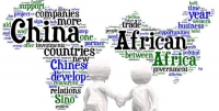
Africa's Relationship With China Is Ancient History
2017/07/02 In 2002 South Africa's Parliament unveiled a digital reproduction of a map - of China, the Middle East and Africa - that some speculated could be the initial map of the African continent. The Da Ming Hun Yi Tu - the Comprehensive Map of the Great Ming Empire - was drawn up around 1389 during the Ming Dynasty, according to historian Hyunhee Park.
Africa: Making Things Happen at the Bank - 'Not a Talk Shop' - Akin Adesina
2017/07/02 Dr. Akinwumi Adesina is focusing on five areas to achieve the African and world goals for a prosperous continent since becoming president of the African Development Bank - Africa's major public financial institution in September 2015. He was a keynote speaker at this month's Corporate Council on Africa's U.S.- Africa Business Summit in Washington D.C. and moderated a lively panel with five African government ministers. He as well received the Gene White Lifetime Succcess Award from the World Child Nutrition Foundation. This week, he was named the 2017 recipient of the World Food Prize, a prestigious honor that includes a $250,000 award. In an interview in Washington, DC, Adesina discussed the Development Bank's ambitious schedule and his vision for attracting the increase capital Africa needs. Posting questions for AllAfrica was Noluthando Crockett-Ntonga.
Climate change laws around the world
2017/05/14 There has been a 20-fold increase in the number of global climate change laws since 1997, according to the most comprehensive database of relevant policy and legislation. The database, produced by the Grantham Research Institute on Climate Change and the Environment and the Sabin Center on Climate Change Law, includes more than 1,200 relevant policies across 164 countries, which account for 95% of global greenhouse gas emissions.
Central Africa Republic Outlook for 2016-17
2016/05/29 The country (Central African Republic) is situated in Central Africa, north of Democratic Republic of the Congo. It has borders with Congo (Kinshasa) for 1577km, Congo (Brazzaville) for 467km, Cameroon for 797km, Sudan for 1165km and Chad for 1197km. Land in Central African Republic is vast, flat to rolling, monotonous plateau, scattered hills in northeast and southwest. Central African land cover an area of 622984 km². Overview The Central African Republic (CAR) is a landlocked country in central Africa, with a people of 4.5 million. The country’s history has been marked by political instability. In 2013, a major security and humanitarian crisis ravaged the country.
- Central Africa Republic News
-
- AFGHANISTAN: UNWTO: International tourism – strongest half-year results since 2010
- BOTSWANA: Why governments need to support the financial sector to meet the unserved needs of smallholder farmers
- BOTSWANA: International Arrivals To Africa Reach More Than 18 Million In 2017
- BOTSWANA: Africa: USA-Africa - No Policy? Bad Policy? or Both?
- BOTSWANA: Africa: U.S. State Department To Get Experienced Diplomat in Key Africa Post
- BOTSWANA: Africa’s economic growth in 2016 was driven by East Africa

- Trending Articles
-
- CHINA: China welcomes Guinea to take part in Belt and Road Initiative
- CAMEROON: Poor End of Year Results for Cameroon Students
- AUSTRALIA: Queensland Bauxite Gains State Approval of Mineral Development Work Program
- KENYA: Kenya to hold fresh presidential election on October 17
- UGANDA: Ugandan Govt Starts Verifying International Academy Teachers
- CANADA: NAFTA renegotiation could be double-edged sword


