


Austria: Austria Geography Profile 2012
2012/02/16
Austria Geography Profile 2012
 Austria is a largely mountainous country due to its location in the Alps. The Central Eastern Alps, Northern Limestone Alps and Southern Limestone Alps are all partly in Austria. Of the total area of Austria (84,000 km2 or 32,433 sq mi), only about a quarter can be considered low lying, and only 32% of the country is below 500 metres (1,640 ft). The Alps of western Austria give way somewhat into low lands and plains in the eastern part of the country.
Austria can be divided into five areas, the biggest being the Eastern Alps, which constitute 62% of nation's total area. The Austrian foothills at the base of the Alps and the Carpathians account for around 12% and the foothills in the east and areas surrounding the periphery of the Pannoni low country amount to about 12% of the total landmass. The second greater mountain area (much lower than the Alps) is situated in the north. Known as the Austrian granite plateau, it is located in the central area of the Bohemian Mass and accounts for 10% of Austria. The Austrian portion of the Vienna basin comprises the remaining 4%.
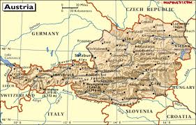
Austria is a small, predominantly mountainous country in Central Europe, approx. between Germany, Italy and Hungary. It has a total area of 83,859 km², about twice the size of Switzerland and slightly smaller than the state of Maine.
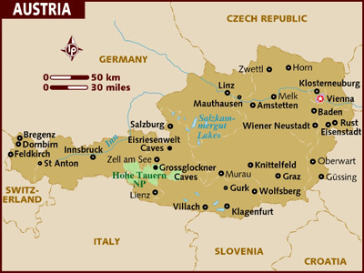 Political geography : The landlocked country shares national borders with Switzerland (164 km) and the tiny principality of Liechtenstein (35 km) to the west, Germany (784 km) and the Czech Republic (362 km) and Slovakia (91 km) to the north, Hungary to the east (346 km), and Slovenia (311 km) and Italy (430 km) to the south (total: 2563 km).
The westernmost third of the somewhat pear-shaped country consists of a narrow corridor between Germany and Italy that is between thirty-two and sixty km wide. The rest of Austria lies to the east and has a maximum north–south width of 280 km. The country measures almost 600 km in length, extending from Lake Constance (German Bodensee) on the Austrian-Swiss-German border in the west to the Neusiedler See on the Austrian-Hungarian border in the east. The contrast between these two lakes – one in the Alps and the other a typical steppe lake on the westernmost fringe of the Hungarian Plain – illustrates the diversity of Austria's landscape.
Seven of Austria's nine provinces have long historical traditions predating the establishment of the Republic of Austria in 1918: Upper Austria, Lower Austria, Styria, Carinthia, Salzburg, Tyrol, and Vorarlberg. The provinces of Burgenland and Vienna were established after World War I. Most of Burgenland had been part of the Kingdom of Hungary, but it had a predominantly German-speaking population and hence became Austrian. Administrative and ideological reasons played a role in the establishment of Vienna as an independent province.
Central Europe, north of Italy and Slovenia
47 20 N, 13 20 E
Europe
slightly smaller than Maine
2,562 km
temperate; continental, cloudy; cold winters with frequent rain and some snow in lowlands and snow in mountains; moderate summers with occasional showers
in the west and south mostly mountains (Alps); along the eastern and northern margins mostly flat or gently sloping
oil, coal, lignite, timber, iron ore, copper, zinc, antimony, magnesite, tungsten, graphite, salt, hydropower
landslides; avalanches; earthquakes
some forest degradation caused by air and soil pollution; soil pollution results from the use of agricultural chemicals; air pollution results from emissions by coal- and oil-fired power stations and industrial plants and from trucks transiting Austria between northern and southern Europe
landlocked; strategic location at the crossroads of central Europe with many easily traversable Alpine passes and valleys; major river is the Danube; population is concentrated on eastern lowlands because of steep slopes, poor soils, and low temperatures elsewhere

- Austria News
-
- AUSTRIA: Austria Private Sector Growth Maintains Strong Momentum
- AUSTRIA: OPEC, non-OPEC agree first global oil pact since 2001
- AFGHANISTAN: Higher earning Why a university degree is worth more in some countries than others
- AUSTRIA: Minister Nkoana-Mashabane to host her Austrian counterpart
- ALBANIA: Europe in 2016: Terror fears, migration, politics. But economy may turn a corner
- AFGHANISTAN: Global growth will be disappointing in 2016: IMF's Lagarde

- Trending Articles
-
- EUROPEAN UNION: UK and EU stuck on 'philosophy' of Brexit bill
- TURKEY: Turkish Supreme Military Council replaces land, air and navy commanders
- VENEZUELA: Venezuelan election turnout figures manipulated by one million votes
- CHINA: China to add freight train service to south Asia
- TANZANIA: Farmers pushed off their land to save Tanzania's Great Ruaha River
- KENYA: Kenya's new $3.2 billion railway frustrates customers ahead of polls


